
Strait of Malacca Map —
Complete Interactive Guide
Explore the world’s most critical maritime waterway with an interactive map. Full guide to geography, shipping routes, trade data, geopolitics, and current affairs — updated May 2026.
Interactive Map
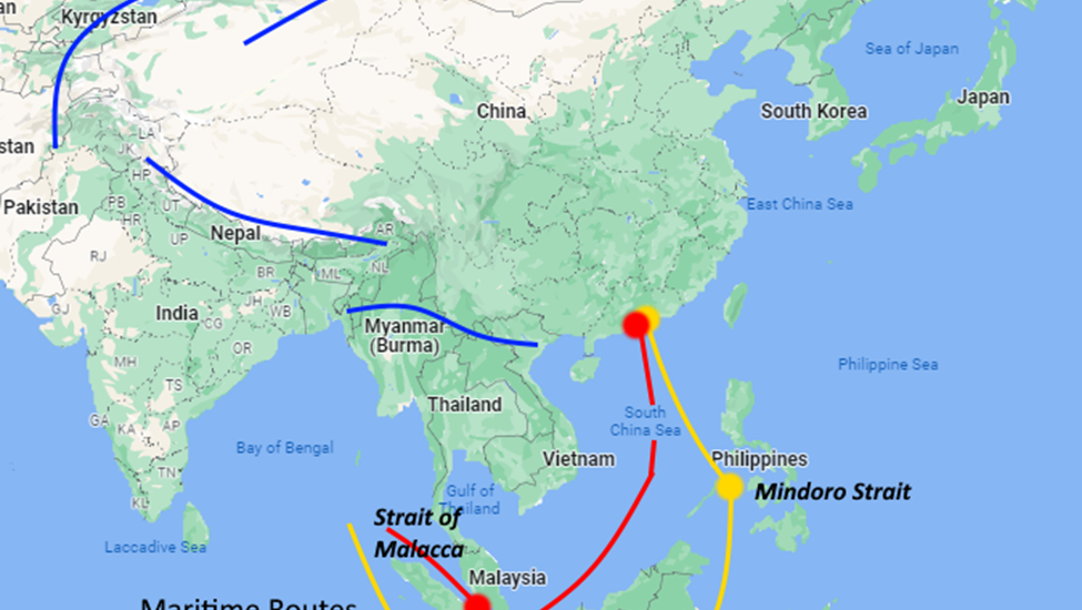
Strait of Malacca — Live Interactive Map
Explore the full extent of the Strait of Malacca, from its northern mouth near the Isthmus of Kra to the Philip Channel at Singapore. Click any marker for details.
Definition & Overview
What is the Strait of Malacca?
The Strait of Malacca is a narrow, naturally occurring channel of water running approximately 900 kilometres (560 miles) between two landmasses: the Malay Peninsula (comprising Malaysia, Singapore, and southern Thailand) to the northeast, and the Indonesian island of Sumatra to the southwest.
It functions as the primary maritime corridor connecting the Andaman Sea — an arm of the Indian Ocean — to the South China Sea, which opens into the Pacific Ocean. In practical terms, this makes it the obligatory sea route for virtually every vessel travelling between the Indian Ocean and East Asia.
The strait is named after the historic port city of Melaka (Malacca), located on the southwestern coast of the Malay Peninsula. According to Malay historical chronicles, the city was founded around 1400 CE by Parameswara, a Srivijayan prince, who named it after the pokok melaka (Indian gooseberry tree) under which he rested when he chose the location.
Why “Strait” — Not “Straight”?
A common misspelling: the correct geographical term is strait — a naturally formed narrow waterway between two larger bodies of water. A “straight” is an adjective. All major maritime chokepoints — Hormuz, Gibraltar, Dover — use “strait.”
The Strait in Simple Terms
Think of the Strait of Malacca as a funnel. It is wide (roughly 250 km) at its northern end near Thailand, and narrows dramatically to just 2.7 km at Philip Channel near Singapore. Every ship — oil tanker, container vessel, bulk carrier — that travels between Europe, the Middle East, or Africa and East Asia must squeeze through this bottleneck.
“Whoever is lord of Malacca has his hand on the throat of Venice.”
— Tomé Pires, Portuguese official, c.1515 — an observation as true today as it was five centuries ago, with “Venice” replaced by the global economyGeography & Dimensions
Strait of Malacca Geography, Width & Physical Characteristics
Understanding the map of the Strait of Malacca requires understanding its funnel-shaped geometry and the physical constraints that make it irreplaceable.
The Depth Constraint
The strait’s shallow depth — averaging 25–27 metres — places a hard limit on vessel size. The world’s largest Ultra Large Crude Carriers (ULCCs) cannot transit the strait fully laden. They must either lighten their cargo or reroute via the deeper Lombok Strait in Indonesia — adding over 1,000 nautical miles to their journey. This depth limitation is, paradoxically, one reason the strait retains so much strategic value: it forces even the largest ships to engage with it at some level of the supply chain.
Strategic Importance
Why the Strait of Malacca Is So Important
1. The World’s Irreplaceable Shipping Lane
The Strait of Malacca provides the shortest sea route between the Indian and Pacific Oceans. The only realistic alternatives — the Lombok Strait and Sunda Strait through Indonesia — are longer, shallower, or harder to navigate. Diversion via Lombok adds roughly 1,000 nautical miles, translating to several extra days at sea and enormous additional cost.
One study estimates that a single day of diversion costs carriers between $9 million and $90 million in additional fuel and logistics expenses.
2. The World’s Dominant Energy Corridor
More than 16 million barrels of oil per day transit the strait — roughly 35% of all oil moved by sea globally. For East Asian economies, dependence is acute: Japan imports approximately 80% of its oil via Malacca; South Korea, 70%; China, over 80%.
3. Nine of Ten Busiest Ports in Its Hinterland
The Indo-Pacific region served by the strait is home to nine of the world’s ten busiest seaports and accounts for roughly 60% of global GDP. Singapore at the strait’s southern tip is the world’s second-busiest container port. Malaysia’s Port Klang and Tanjung Pelepas are major transhipment hubs.
4. The China Malacca Dilemma
In 2003, Chinese President Hu Jintao coined the term “Malacca Dilemma” to describe a profound strategic vulnerability: with roughly 80% of China’s imported crude oil passing through this single narrow passage, a naval blockade — by the United States or India — could cripple China’s economy without a shot fired on Chinese soil.
Despite investments in alternative routes (Myanmar pipelines, Central Asian corridors, Gwadar Port), none comes close to Malacca’s capacity. The dilemma remains unresolved.
5. A 1,500-Year-Old Trade Route
The Strait of Malacca has been the backbone of Asian maritime trade since at least the 1st century CE, when it formed part of the ancient Maritime Silk Road connecting Rome, India, and China. The Srivijaya Empire controlled it for 700 years. The Malacca Sultanate, the Portuguese, Dutch, and British all fought to dominate it. Today, its strategic centrality has only grown.
Trade Volume & Data
Strait of Malacca Trade Volume, Statistics & Data 2025–2026
The numbers that define the world’s most important waterway — updated with the latest 2025 vessel reporting data.
Chokepoint Comparison: Oil Flow
How does the Strait of Malacca compare to other major maritime chokepoints by daily oil throughput?
Source: U.S. Energy Information Administration (EIA), 2023–2024 data
Current Affairs · May 2026
The Strait of Malacca in 2026 — What’s Happening Now
The Strait of Malacca is at the centre of global geopolitical attention in 2026. Here is the current state of affairs.
Hormuz Crisis Puts Malacca Under Spotlight
Iran’s effective closure of the Strait of Hormuz since late February 2026 has forced global attention onto the Strait of Malacca as the next critical chokepoint. With Hormuz blocked, energy markets are scrambling for alternatives — amplifying the strategic significance of every ship transiting Malacca.
US–Indonesia Major Defence Partnership (April 2026)
On April 14, 2026, the United States and Indonesia signed a Major Defence Cooperation Partnership (MDCP), covering military modernisation, joint training, and maritime defence. The US is also seeking expanded access to Indonesian airspace — a development of enormous strategic weight given Indonesia’s sovereignty over key alternative routes around the strait.
Record Vessel Traffic in 2025
The Strait of Malacca recorded its highest-ever vessel transit numbers in 2025 — up 8.72% from 2024’s 94,301 transits. Container ships (74/day), tankers (60/day), and dry bulk carriers (57/day) are the dominant traffic categories. Deep-draught VLCC transits have nearly doubled over the past decade.
Indonesia Floats — Then Backs Down On — Transit Tolls
In April 2026, Indonesia’s finance minister raised the idea of charging transit tolls on vessels passing through the strait. The proposal drew immediate international opposition. Indonesia’s foreign minister subsequently confirmed no tolls would be imposed, citing UNCLOS, which explicitly prohibits littoral states from charging for transit passage.
Thailand Land Bridge: Cabinet Proposal Due June–July 2026
Thailand’s proposed $31 billion Land Bridge — linking Ranong on the Andaman Sea to Chumphon on the Gulf of Thailand — is accelerating, with a formal Cabinet proposal expected in June–July 2026. If built, it would allow cargo to bypass the southern section of the Malacca route entirely. Critics question whether transshipment costs negate the time savings.
Great-Power Military Build-Up Around the Strait
Both the US (via base access and naval deployments) and China (via its port network and blue-water naval expansion) have been steadily expanding their military presence in the strait’s approaches. India monitors from the strategically placed Andaman and Nicobar Islands. Analysts warn the strait is becoming a flashpoint for great-power competition.
Bordering Countries
Which Countries Border — and Depend On — the Strait of Malacca?
The Three Littoral States
Three nations hold sovereignty over the territorial waters within the strait and bear joint responsibility for its management, safety, and environmental protection:
| Country | Role |
|---|---|
| 🇲🇾Malaysia | Northeast shore. Home to Port Klang (world’s 12th busiest) and Tanjung Pelepas. |
| 🇮🇩Indonesia | Southwest shore — entire Sumatran coastline. Holds co-sovereignty and controls alternative Lombok/Sunda straits. |
| 🇸🇬Singapore | Southern tip. World’s 2nd busiest port. The world’s premier transshipment and bunkering hub. |
| 🇹🇭Thailand | Northern tip at Isthmus of Kra — where the Thailand Land Bridge project is proposed. |
Major Economies Dependent on the Strait
These nations route the majority of their energy and manufactured goods imports through the strait:
| Country | Oil Dependence on Malacca |
|---|---|
| 🇨🇳China | ~80% of oil imports |
| 🇯🇵Japan | ~80% of oil imports |
| 🇰🇷South Korea | ~70% of oil imports |
| 🇮🇳India | Major trade corridor |
| 🇹🇼Taiwan | Critical electronics supply chain |
Frequently Asked Questions
Strait of Malacca — Most Asked Questions
Answers to the questions people search most about the Strait of Malacca — based on geography, trade, geopolitics, and current affairs.
Where is the Strait of Malacca on a map?
The Strait of Malacca runs between the Malay Peninsula (Malaysia, Singapore, southern Thailand) to the northeast and the Indonesian island of Sumatra to the southwest. See the interactive map above for its precise location.
In coordinate terms, the strait runs from approximately 6°N, 99°E in the north (near the Isthmus of Kra, Thailand) to 1°N, 104°E in the south (Philip Channel, Singapore). It connects the Andaman Sea to the South China Sea — and through them, the Indian Ocean to the Pacific Ocean.
How wide is the Strait of Malacca at its narrowest point?
At Philip Channel, near Singapore, the Strait of Malacca narrows to just 2.7–2.8 kilometres — roughly 1.7 miles. This is barely wider than the turning radius of a modern ultra-large container ship. All traffic — regardless of vessel type or size — must converge through this extraordinarily narrow passage.
By contrast, the strait’s widest point near Thailand measures approximately 250 kilometres. The dramatic narrowing from 250 km to 2.7 km over 900 km is what creates the “funnel” that gives the strait its bottleneck power.
Is the Strait of Malacca the world’s busiest?
Yes — by vessel count, the Strait of Malacca (together with the adjacent Singapore Strait) is the world’s busiest shipping strait. In 2025, it recorded its highest-ever transit numbers: over 100,000 vessels — up 8.72% from 94,301 in 2024, equating to approximately 281 ship reports per day to Malaysia’s Klang VTS (Vessel Traffic Service).
The four largest categories by daily average in 2025 were: container ships (74/day), tankers (60/day, excluding laden VLCCs), dry bulk carriers (57/day), and deep-draught vessels including VLCCs (28/day — nearly doubled in a decade).
What is the “Strait of Malacca Dilemma”?
The “Malacca Dilemma” was a term coined by Chinese President Hu Jintao in 2003 to describe China’s acute strategic vulnerability: with roughly 80% of China’s imported crude oil transiting this single narrow passage, any naval adversary capable of blockading Philip Channel — most plausibly the United States or India — could bring China’s economy to its knees without firing a shot on Chinese soil.
China has invested heavily in alternatives — overland pipelines through Myanmar and Central Asia, Gwadar Port in Pakistan, and naval bases across the Indian Ocean (the “String of Pearls”). None has come close to solving the dilemma. The Myanmar pipeline handles ~440,000 barrels per day; China’s daily oil import need is roughly 11 million barrels. The dilemma remains structurally unresolved.
Who owns or controls the Strait of Malacca?
No single nation owns or controls the Strait of Malacca. Under the United Nations Convention on the Law of the Sea (UNCLOS), the strait is classified as an international navigation corridor. All vessels — regardless of flag — have an unimpeded right of “transit passage.”
The three littoral states — Malaysia, Indonesia, and Singapore — each exercise sovereignty over their respective 12-nautical-mile territorial waters within the strait. However, that sovereignty does not permit them to close the strait or charge transit fees. UNCLOS Articles 37–44 explicitly prohibit this. Their role is that of joint stewards, not gatekeepers: managing traffic safety, combating piracy, and protecting the marine environment.
Strategically, the US Navy maintains dominant regional presence; India monitors from the Andaman and Nicobar Islands; and China has been expanding its blue-water naval capability partly to contest potential adversary control.
How does the Strait of Malacca compare to the Strait of Hormuz?
Both are critical global chokepoints, but they differ in important ways. By oil volume alone, Hormuz edges it slightly (17M vs 16M barrels per day). But by total trade value and breadth, Malacca is the more consequential chokepoint — it carries containers, bulk goods, vehicles, food, and critical minerals in addition to energy, serving 12+ major economies simultaneously.
Crucially, Malacca is far harder to replace. Hormuz has theoretical overland pipeline alternatives (though limited capacity). Malacca’s alternatives — Lombok and Sunda Straits — add 1,000–1,500 nautical miles. In 2026, with Hormuz effectively closed by Iran’s military action, attention has shifted sharply to Malacca as the next critical vulnerability in global supply chains.
Why is it called the Strait of Malacca — and what does “Malacca” mean?
The strait takes its name from the historic port city of Melaka (Malacca), which controlled trade through these waters during the height of the Malacca Sultanate in the 15th century.
According to the Sejarah Melayu (Malay Annals), the city was founded by the Srivijayan prince Parameswara around 1400 CE. Resting under a pokok melaka (Indian gooseberry tree, Phyllanthus emblica), he watched a tiny mouse deer kick one of his hunting dogs into the river — taking this as an auspicious omen, he named his new kingdom after the tree.
Alternative etymologies include: Arabic Malakat (“congregation of merchants”); Arabic Malqa (“meeting place”); or Javanese mlayu (“to run”). Under Portuguese, Dutch, and British colonial rule, the spelling varied — today Malaysia officially uses the Malay spelling Melaka.
What would happen if the Strait of Malacca were closed or blocked?
A closure of the Strait of Malacca would be a global economic catastrophe. The immediate effects would include: a sharp spike in global oil prices, as 16 million barrels per day of oil flow would need to be rerouted; severe shortages of semiconductors, electronics, and manufactured goods from East Asian suppliers; disruption of automotive supply chains (particularly electric vehicles); and food price shocks as grain and agricultural commodity flows were interrupted.
The knock-on effects would cascade across every continent. Alternative routes via Lombok and Sunda Straits add 3–5 days and significant cost — and lack Singapore’s world-class refuelling and transshipment infrastructure. A sustained closure would likely trigger recession in Japan, South Korea, and Taiwan within weeks, and severely stress China’s economy within months.